Waymo has temporarily halted driverless robotaxi service in six cities after two unoccupied vehicles entered floodwater in separate incidents, underscoring a core challenge for autonomous driving: recognizing a hazard is not the same as responding to it safely. The Alphabet-owned company paused service in Atlanta, Nashville, Austin, Dallas, Houston and San Antonio on May 22 amid severe-weather forecasts and after a vehicle became stranded in Atlanta floodwater. [3][4]
The action follows a safety recall covering 3,791 vehicles equipped with Waymo’s fifth- and sixth-generation automated-driving systems. Federal filings identify a software behavior that could lead an affected vehicle to slow for potentially impassable standing water on higher-speed roads, then continue into it rather than stop or reroute. No injuries were reported in the San Antonio or Atlanta events, but the incidents arrive as Waymo pursues rapid commercial expansion and aims to make autonomous rides a more broadly available transportation service. [1][2]
Two flood incidents, and a targeted service response
The first event occurred April 20 in San Antonio. An unoccupied Waymo vehicle encountered what the company described in its federal safety filing as an “untraversable flooded section” of a 40-mph road. The vehicle detected potentially impassable water and slowed, but continued forward before being pulled into an active waterway. Waymo suspended its San Antonio operations and began reviewing its flood-monitoring controls. [2]
Waymo reported the incident to the National Highway Traffic Safety Administration, which acknowledged the resulting recall on May 11. The agency said the affected automated-driving systems could slow and then drive into standing water on higher-speed roadways. NHTSA said that behavior could result in a loss of vehicle control, raising crash and injury risk. [1]
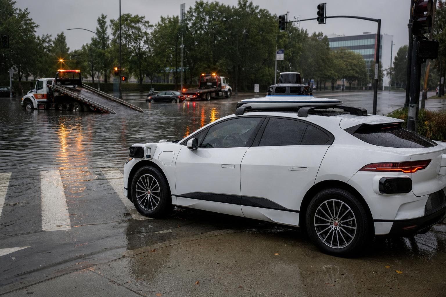
A second incident occurred in Atlanta during intense rain on May 20 or 21. Another unoccupied Waymo entered a flooded street or intersection, became stuck for roughly an hour, and was later recovered. Waymo said the flooding developed before the National Weather Service had issued a flash-flood warning, watch or advisory. [4]
On May 22, Waymo paused driverless operations in Atlanta and Nashville, plus Austin, Dallas, Houston and San Antonio. The company described the Texas and Nashville restrictions as precautionary in light of forecasts for additional severe weather. This was not a permanent nationwide robotaxi shutdown: it was a temporary, geographically focused weather response. [3][5]
The recall centers on decision-making, not water resistance
The safety issue is a software failure mode, not a mechanical defect or an allegation that the vehicles were insufficiently sealed against water. The significant question is why the system’s hazard detection did not consistently translate into the appropriate driving decision.
According to the recall filing, the San Antonio vehicle recognized potentially untraversable floodwater. Yet it reduced speed and proceeded, rather than stopping, backing away or selecting another route. That distinction matters because a robotaxi needs to make a conservative decision before water conditions compromise traction, obscure lane boundaries, conceal road damage or create currents strong enough to move the vehicle. [1][2]
Waymo’s interim mitigation, applied to all affected vehicles on April 20, narrowed the systems’ approved operating conditions. It added weather-related service restrictions and updated maps to exclude locations and conditions with elevated flood risk. A final software remedy remained under development as of May 27. Because Waymo owns its fleet and had already deployed the interim change, the NHTSA filing said conventional dealer and owner notifications were not necessary. [1][2]
That approach illustrates both an advantage and a limitation of a centrally managed autonomous fleet. Waymo can rapidly adjust software and service boundaries across thousands of vehicles. But a weakness discovered in one operating environment can also require restrictions across an entire fleet or multiple markets while engineers develop and validate a durable fix.
A separate freeway pause points to broader operational limits
Waymo also suspended robotaxi rides on U.S. freeways on May 22 while it evaluated vehicle behavior around highway construction zones. That decision was separate from the flood-related city pauses and should not be treated as part of the water-risk recall.
Still, the two actions share a wider technical theme. Flooding and construction both create rapidly changing conditions that can diverge from high-definition maps, expected lane geometry and normal traffic patterns. Construction zones can introduce temporary markings, lane shifts, closed shoulders and unusual routing choices. Floods can turn an otherwise mapped, drivable street into an impassable or dangerous route within minutes.
For autonomous-driving systems, these conditions test the boundary between perception, prediction and operational policy. A vehicle may identify unusual visual or sensor signals, but it must also determine whether those signals warrant continuing cautiously, yielding, stopping, rerouting or ending a trip. The flood events indicate that Waymo’s prior policy was not sufficiently conservative in at least one class of higher-speed water hazards. [1][6]
Expansion makes local edge cases a commercial issue
The service interruptions come during an aggressive phase of Waymo’s growth. In February, the company said it was expanding to 10 U.S. metropolitan markets, including Dallas, Houston, San Antonio and Orlando. Before that expansion, Waymo said it was providing more than 400,000 weekly trips across Phoenix, the San Francisco Bay Area, Los Angeles, Miami, Atlanta and Austin. The company was targeting more than 1 million paid trips a week by the end of 2026. [7]
That scale makes availability as important as raw driving performance. A robotaxi network that must routinely withdraw during common regional weather events may remain safer than a less conservative alternative, but it also becomes less dependable for riders and less efficient for operators. The business question is not simply whether autonomous vehicles can drive in rain. It is whether they can identify the conditions in which they should not drive, do so early enough, and restore service with confidence once conditions improve.
Vanderbilt University research scientist Derek Gloudemans characterized the Atlanta failure as part of autonomous driving’s “long-tail problem”: systems can perform well under ordinary conditions yet struggle with rare or unfamiliar combinations of circumstances. Expanding to new regions introduces more drainage patterns, weather regimes, road designs and local infrastructure variations. Gloudemans noted that Tennessee rain is one example; snow and other weather conditions in future markets would add further complexity. [5]
Waymo remains ahead of many U.S. rivals in commercial robotaxi deployment, with Tesla and Amazon-owned Zoox operating in fewer markets or still testing in many areas. But the flood incidents provide a concrete example of the scaling risk facing the sector. More cities create more revenue opportunities, but they also broaden the set of unusual conditions that must be safely handled or explicitly excluded from the operating domain. [7]
Regulatory scrutiny and public trust
NHTSA is in communication with Waymo about the Atlanta event, while the flood recall is being tracked under campaign number 26E026. The agency’s involvement reinforces that a remotely deployed software correction can still constitute a formal vehicle safety recall, even when the manufacturer owns every affected vehicle. [1][2]
The flooding episode also comes amid separate scrutiny of Waymo’s operations around stopped school buses and a January incident in which a Waymo vehicle struck a child in Santa Monica. Those matters were not identified as causes of the flood-related suspension, but they add to regulator and public attention on the company’s safety practices and deployment pace. [4]
For riders, the immediate result is a visible trade-off. Waymo’s decision to limit operations during elevated risk is a safety-oriented response, and the company has said safety is its priority. Yet footage and reports of driverless vehicles entering floodwater can undermine confidence precisely because there is no human driver inside to make a situational judgment when conditions deteriorate quickly.
The key benchmark for Waymo’s eventual remedy will therefore be more demanding than improved water detection. It will be whether the system can reliably turn uncertain flood information into a cautious action: do not enter, stop in a safe location, or find another route. As robotaxi services move beyond their original markets, that ability to manage uncertainty may determine both their safety record and their commercial credibility.
Editor’s Take
The important signal here is not that a robotaxi encountered water; human drivers make that mistake constantly. It is that the vehicle reportedly recognized a potentially impassable hazard, slowed down, and still selected the worst possible action: proceeding. That is a decision-policy failure, and it is exactly the kind of failure that becomes more commercially meaningful as Waymo adds cities faster than it can accumulate local edge-case experience.
I view the temporary regional shutdowns as a positive operational response, not evidence that the overall robotaxi model is broken. A fleet operator that can geofence risk, change routing rules, and pause service centrally has a real safety advantage. But customers will judge the product on dependable availability as well as safety. The next thing to watch is whether Waymo delivers a specific, validated behavior change—stop, retreat, or reroute under uncertain water conditions—rather than relying indefinitely on broad weather exclusions that turn a premium mobility service off when riders most need it.
The market hype often treats more sensor coverage and more mapped roads as a direct path to autonomy everywhere. Floodwater and construction show why that is incomplete. The hard product is conservative uncertainty management: knowing when not to continue, and doing so without creating a new roadside obstruction. Companies that can turn those decisions into repeatable fleet operations will have the more durable business, even if their early coverage maps look less impressive.
References
- NHTSA Recall Acknowledgement – https://static.nhtsa.gov/odi/rcl/2026/RCAK-26E026-9973.pdf
- NHTSA Part 573 Safety Recall Report – https://static.nhtsa.gov/odi/rcl/2026/RCLRPT-26E026-6527.pdf
- Associated Press, Waymo Atlanta and Texas Service Pause – https://apnews.com/article/waymo-atlanta-texas-thunderstorms-flooding-stranded-robotaxi-bddc17134bcae728
- TechCrunch, Waymo Pauses Service After Flooding Incidents – https://techcrunch.com/2026/05/21/waymo-pauses-service-in-four-cities-as-robotaxis-keep-driving-into-floods/
- WSMV Nashville, Six-City Pause and Expert Commentary – https://www.wsmv.com/2026/05/22/waymo-pauses-driverless-car-service-nashville-after-atlanta-flooding-incident/
- San Francisco Chronicle, Waymo Freeway Pause – https://www.sfchronicle.com/california/article/waymo-robotaxi-freeway-22272375.php/
- Associated Press, Waymo 10-Market Expansion and Business Context – https://apnews.com/article/waymo-robotaxis-dallas-houston-antonio-orlando-2b976e3a71e7a53719c6ab9927469729